EN
'%3e%3cpath%20d='M9.23294%208.275L4.08176%204.5H9.24529V8.275H9.23294ZM18.8188%204.5H14.7671V7.4625L18.8188%204.5ZM22.5%209.1125C22.5%207.975%2022.5%206.8875%2022.5%205.925L18.2012%209.1125H22.5ZM1.5%206.8375V9.1125H4.61294L1.5%206.8375ZM14.7671%2019.5H19.9306L14.7671%2015.725V19.5ZM5.18118%2019.5H9.23294V16.5375L5.18118%2019.5ZM1.5%2014.8875C1.5%2016.025%201.5%2017.1125%201.5%2018.075L5.79882%2014.8875H1.5V14.8875ZM22.5%2017.1625V14.8875H19.3871L22.5%2017.1625Z'%20fill='%230034A9'/%3e%3cpath%20d='M21.6847%204.5H22.5C22.5%204.925%2022.5%205.4125%2022.5%205.925L18.2012%209.1125H22.5C22.5%209.5%2022.5%209.875%2022.5%2010.275H13.6553V4.5H14.7547V7.4625L18.8188%204.5H19.7824L14.7671%208.1625V9.1125H15.3847L21.6847%204.5ZM10.3447%2010.275H1.5V9.1125H4.61294L1.5%206.8375V4.5H4.08176L9.24529%208.275V4.5H10.3447V10.275V10.275ZM7.50353%209.1125L1.5%204.725V6.1375L5.57647%209.1125H7.50353V9.1125ZM8.61529%2014.8875H9.23294V15.8375L4.21765%2019.5H5.18118L9.23294%2016.5375V19.5H10.3324V13.725H1.5C1.5%2014.125%201.5%2014.5%201.5%2014.8875H5.79882L1.5%2018.075C1.5%2018.5875%201.5%2019.075%201.5%2019.5H2.31529L8.61529%2014.8875ZM13.6553%2013.725H22.5V14.875H19.3871L22.5%2017.1625V19.5H19.9182L14.7547%2015.725V19.5H13.6553V13.725ZM16.4965%2014.8875L22.5%2019.275V17.8625L18.4235%2014.8875H16.4965V14.8875Z'%20fill='white'/%3e%3cpath%20d='M14.7671%208.1625L19.7824%204.5H21.6971L15.3971%209.1125H14.7794V8.1625H14.7671ZM1.5%206.1375L5.57647%209.1125H7.50353L1.5%204.725V6.1375ZM13.6553%2010.275V4.5H10.3447V10.275H1.5V12C1.5%2012.575%201.5%2013.15%201.5%2013.725H10.3447V19.5H13.6553V13.725H22.5V12C22.5%2011.425%2022.5%2010.85%2022.5%2010.275H13.6553ZM9.23294%2014.8875H8.61529L2.31529%2019.5H4.21765L9.23294%2015.8375V14.8875ZM22.5%2017.8625L18.4235%2014.8875H16.4965L22.5%2019.275V17.8625Z'%20fill='%23D7280F'/%3e%3c/g%3e%3c/svg%3e)
EN
ABOUT
The program calculates takeoff and landing characteristics using an automated algorithm for calculation, compiled in direct accordance with the Flight Manual of a specific type of aircraft, based on such initial parameters as the weight of the aircraft, weather conditions, and runway characteristics.
PECULIARITIES
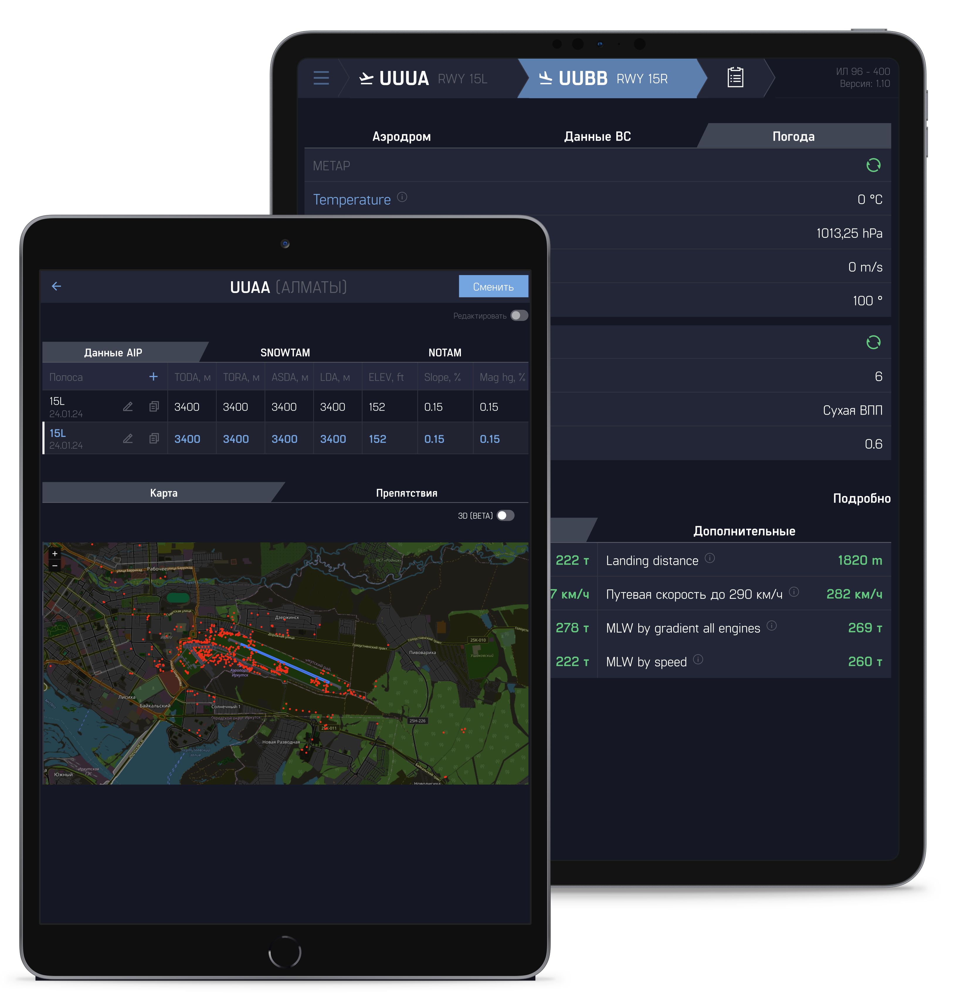
Our tool covers the full range of capabilities: calculation of key parameters, integration with METAR and AIP data, access to current airfield directories, as well as the creation of convenient and visual printed versions of calculations.

CALCULATION OF ANY PARAMETERS
Calculation of any aircraft takeoff and landing characteristics based on primary documentation

PRINTED VERSION OF THE CALCULATION
Saving and printing of two types of documents, detailed and abbreviated version of the calculation

DATA METAR / AIP
Automatic loading of data into calculation input parameters:
-METAR (pressure, temperature, wind strength and direction)
-AIP (take-off and landing distances, runway characteristics and obstacle data)

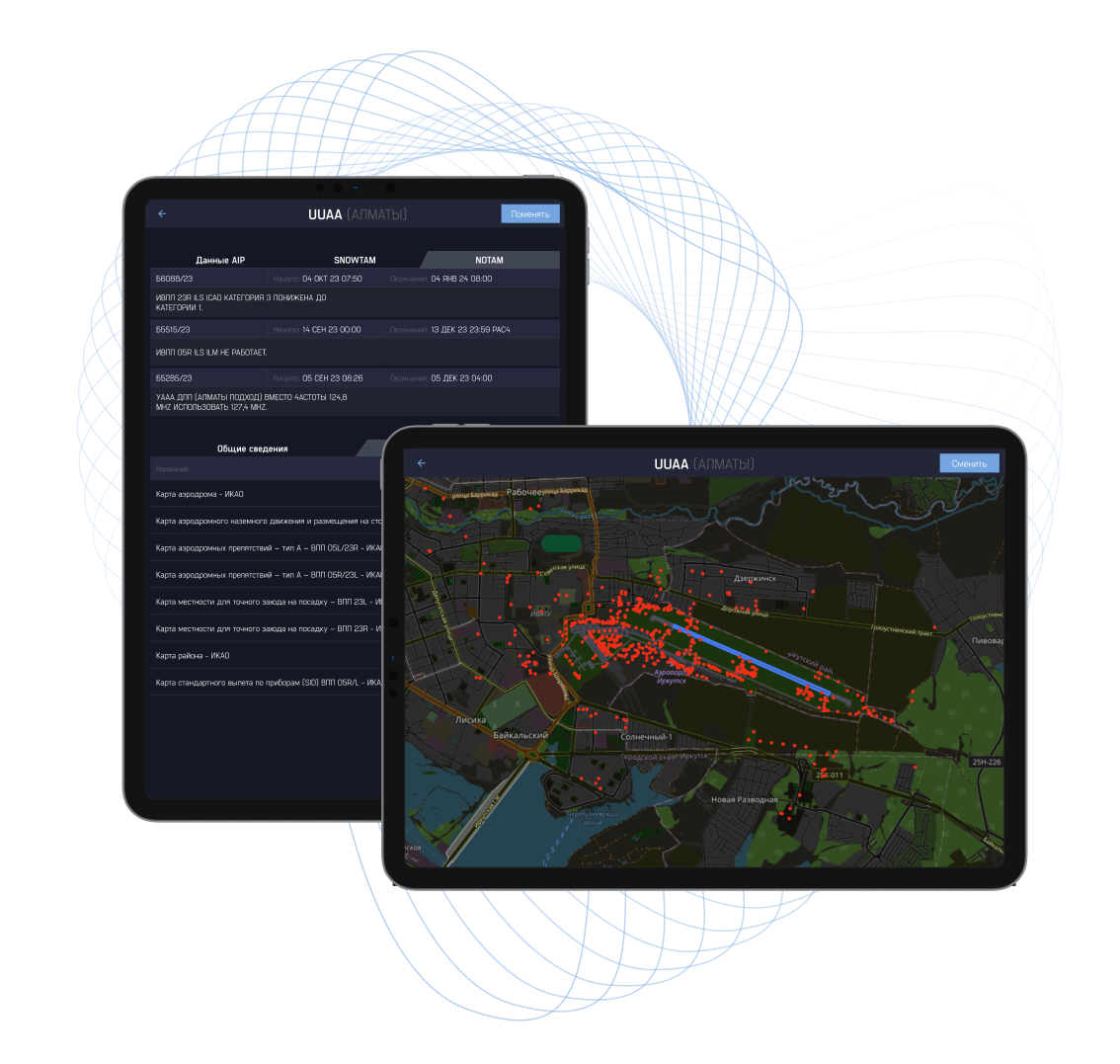
AERODROME DIRECTORIES
Availability of an up-to-date database on airfields with the ability to view information:
-AIP
-SNOWTAM
-NOTAM
CONSTRUCTION OF CALCULATION
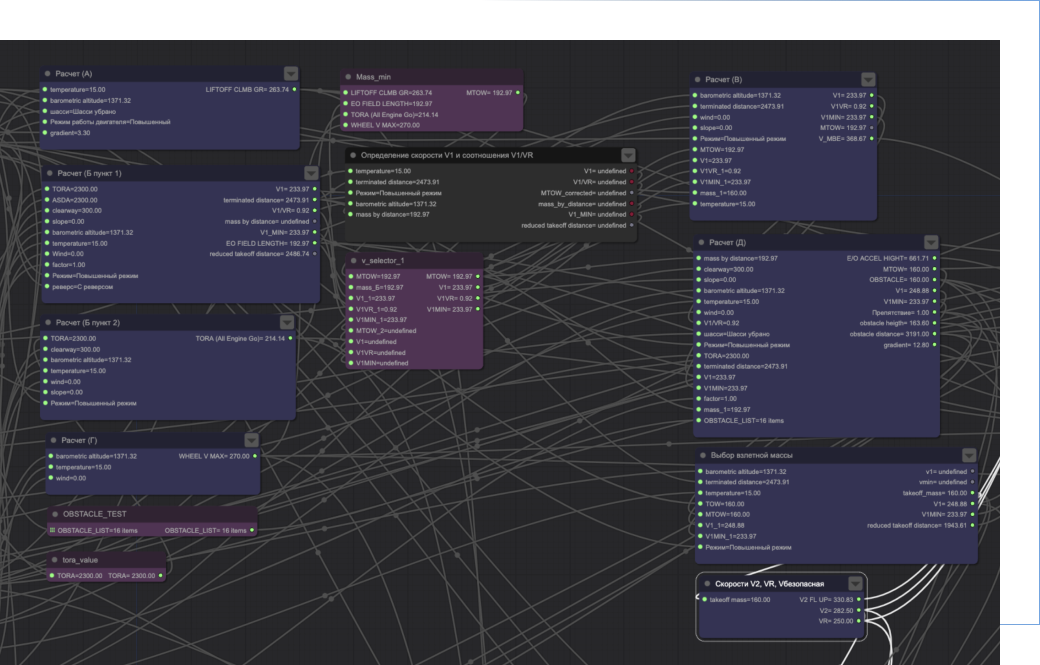
To ensure accuracy and reliability, all calculations in the program are based on primary documentation provided by the aircraft manufacturer. The algorithms are based on certification data, operational limitations and recommendations found in the Flight Manual (AFM) and other official sources.

Taking into account the individual characteristics of each aircraft model
Ensure that calculations meet established safety and efficiency standards
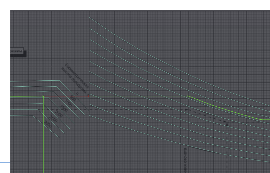
The program visualizes the calculation methodology using nomograms, which greatly simplifies the process of data analysis. A visual representation allows you to control each stage of calculations, identify possible inconsistencies and eliminate errors.Thanks to this, users can be confident in the accuracy of the results and the correctness of the calculations performed. This approach makes the calculation process not only more transparent, but also convenient for prompt decision-making.
Accuracy of calculation results
Control of each stage of calculations
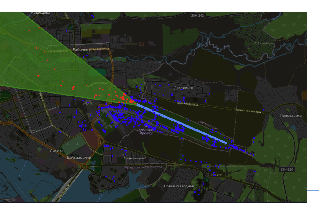
The airfield obstacle map provides visual information about the location of all significant objects that can affect takeoff and landing. With its help, pilots and operators can quickly analyze terrain features, assess risks and make optimal decisions to ensure flight safety. Current map data is updated in accordance with international standards and requirements.
Visual display of obstacles on the airfield map
Interactive construction of a runway take-off cone with display of limiting obstacles
View detailed information on obstacles on Obstacle-chart
LEAVE A REQUEST
Fill out the form and we will contact you
Type of activity

Airline
Business jet operator
Other
'%3e%3cmask%20id='mask0_2443_288537'%20style='mask-type:alpha'%20maskUnits='userSpaceOnUse'%20x='1'%20y='4'%20width='22'%20height='16'%3e%3cpath%20d='M20.5%204.5H3.5C2.39543%204.5%201.5%205.39543%201.5%206.5V17.5C1.5%2018.6046%202.39543%2019.5%203.5%2019.5H20.5C21.6046%2019.5%2022.5%2018.6046%2022.5%2017.5V6.5C22.5%205.39543%2021.6046%204.5%2020.5%204.5Z'%20fill='white'/%3e%3c/mask%3e%3cg%20mask='url(%23mask0_2443_288537)'%3e%3cpath%20d='M20.5%204.5H3.5C2.39543%204.5%201.5%205.39543%201.5%206.5V17.5C1.5%2018.6046%202.39543%2019.5%203.5%2019.5H20.5C21.6046%2019.5%2022.5%2018.6046%2022.5%2017.5V6.5C22.5%205.39543%2021.6046%204.5%2020.5%204.5Z'%20fill='%230034A9'/%3e%3cpath%20fill-rule='evenodd'%20clip-rule='evenodd'%20d='M1.5%2014.5H22.5V19.5H1.5V14.5Z'%20fill='%23D7280F'/%3e%3cpath%20fill-rule='evenodd'%20clip-rule='evenodd'%20d='M1.5%204.5H22.5V9.5H1.5V4.5Z'%20fill='white'/%3e%3c/g%3e%3c/g%3e%3cdefs%3e%3cclipPath%20id='clip0_2443_288537'%3e%3crect%20width='21'%20height='15'%20fill='white'%20transform='translate(1.5%204.5)'/%3e%3c/clipPath%3e%3c/defs%3e%3c/svg%3e)